SDI Governance and Allocation of Tasks
How SDI perfom in comparison with others SDI's, learning from best practices and options for improvement
WELCOME!
The following modules give an overview of the non-technical aspects related to Spatial Data Infrastructures (SDI). This training material aims to guide and improve skills of SDI owners and managers.
This course material has been developed using tools, concepts and guidelines under the framework of the EO4GEO project. Unless stated otherwise, all rights for figures and additional material are with the author(s).
You can navigate through the course by pressing the navigation arrows at the bottom of each slide or using your arrow keys on your keyboard. You can move horizontally (← →) for viewing each theme and vertically (↑↓) to navigate through its contents.
SDI performance and assessment
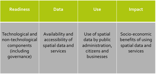
SDI – Definition
- Collection of technological and non-technological components (readiness)
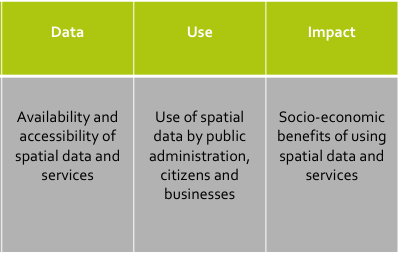
- To facilitate and improve the access to and sharing of spatial data (data)
- In order to stimulate the use of these data by different types of users (use)
- And to promote better decision-making and therefore better social, economic and environmental outcomes (impact)
SDI - Conceptual framework
SDI - Conceptual framework


This lecture
Governance (including the allocation of tasks)
SDI performance and assessment
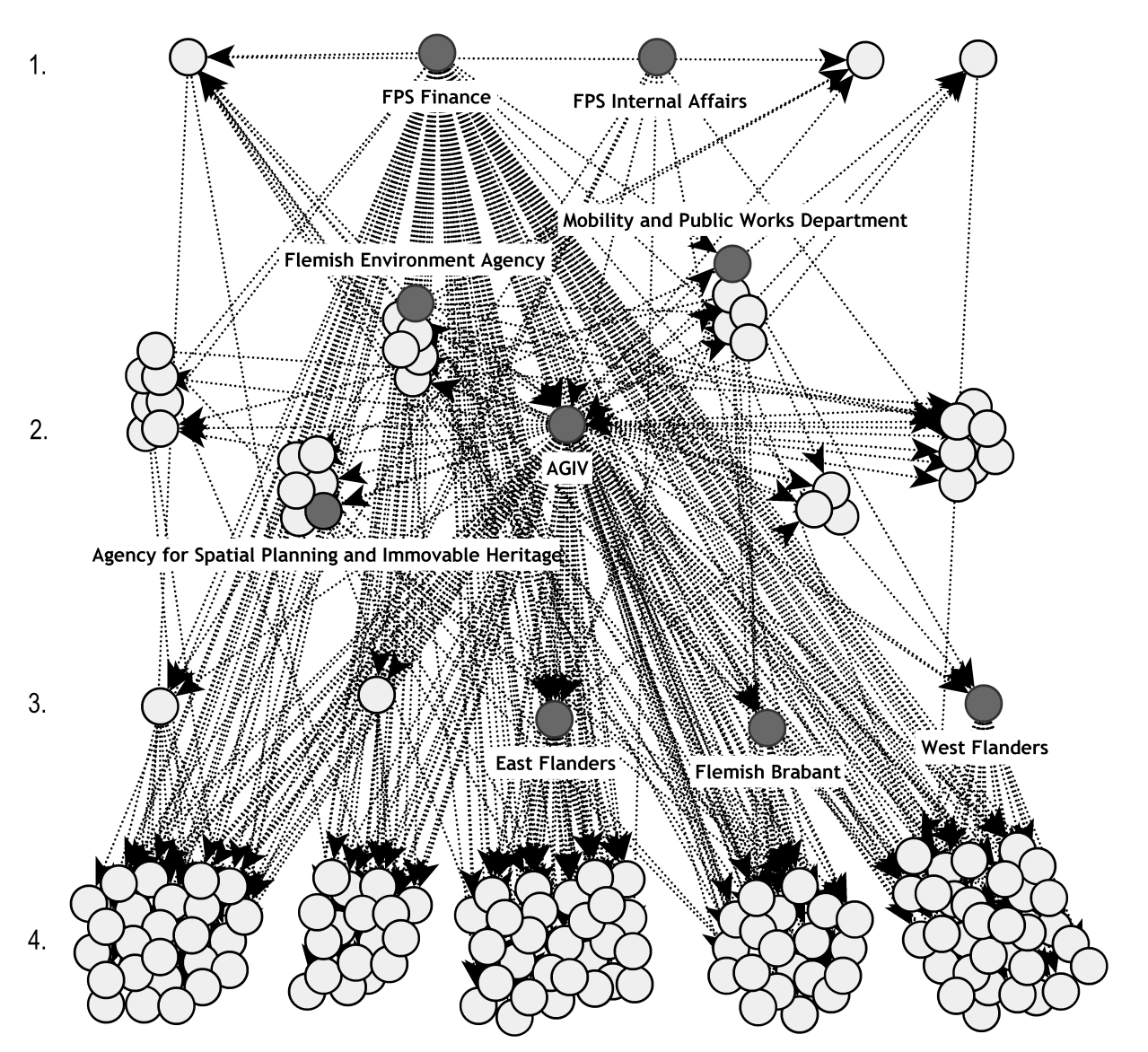
Learning activity (introduction)
Questions:
- What do you see in this picture?
- Which elements do you recognize?
- What does the complete picture show?
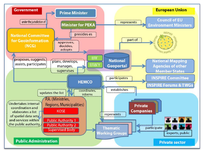
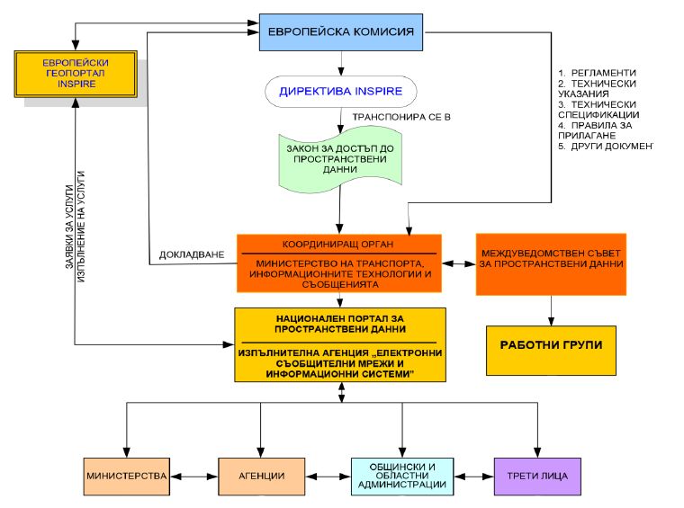
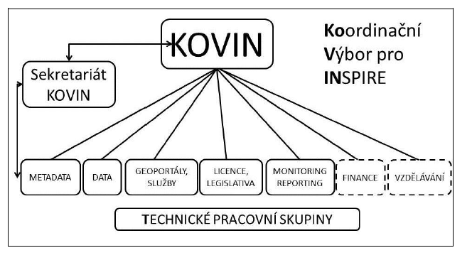
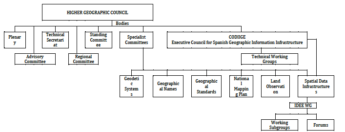
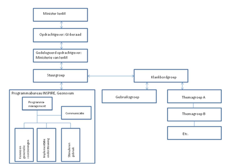
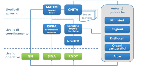
Elements covered in these organization charts
- Actors: who is involved in the SDI
- Allocation of tasks: who is doing what
- Decision making: where/how, and who is involved
- Other relationships: communication, exchange/publication of data
--> Visual representation of the SDI governance structure
Governance - Definition
The sum of the many ways in which individuals, institutions, public and private, manage their common affairs. It is the continuing process through which conflicting or diverse interest maybe accommodated and cooperative action taken
(Commission on Global Governance, 1995)
SDI Governance – two definitions
The structures, policies, actors and institutions by which the infrastructure is managed through decisions and agreements on accessing, sharing, exchanging and using the relevant available spatial information.
The governance of SDIs deals with the adoption of structures, procedures and instruments for managing the relationships and dependencies between all involved actors, units and organizations. The central challenge of governance is reconciling collective and individual needs and interests of different stakeholders in order to achieve common goals
SDI performance and assessment
Why governance of SDI is needed?
- Fragmentation
- (Inter)dependencies
1. Fragmentation
- “First generation of SDIs” (Masser, 1999)
- Mainly led by data producers
- At central level of government (national mapping agencies)
- Focus on data creation and production
- Within existing – centralized - structures
→ Many different actors/institutions involved (fragmentation)
Next generation(s) of SDIs
- Stronger focus on user needs
- Other thematic domains (environment, spatial planning, mobility, statistics, health, etc.)
- Lower levels of government
- Producers and users outside the public sector
- Many different SDIs
→ even more different actors/institutions involved (increased fragmentation)
Actors in SDI implementation
- In principle, all public authorities should be considered as a (potential) provider and/or user of spatial data, and thus as a node in the SDI network.
- Actors at different administrative levels:
- Municipal, local, regional, national, European, international
- Actors in different policy fields:
- Environment, mapping agencies, cadastral agencies
- Other fields…
Agriculture, Mobility, Spatial planning, Statistics
Actors - third parties
- While the original focus of the SDI was on the public sector, also actors from the private sector, academic sector and non-profit sector can be added to network, as data providers and/or data user.
- Agreement should be found on the terms and conditions for access and use of data sets and services for non-public organizations and these terms and conditions should be included in the partnership agreement.
- Partners should also determine the basic requirements these non-public authorities need to fulfill in case they want to add their data to the SDI. Non-public authorities should be recommended to apply the same conditions for usage as the public data providers.
- Also non-governmental actors might be given the opportunity to be involved in the coordination of the SDI, in a decision-making or advisory role.
Actors - third parties
Almost 500 actors (only in the public sector)
2. Dependencies between actors
- Actors in an SDI strongly dependent on each other
- Producer – consumer relationships (or provider-user relationships)
- Task/subtask relationships (e.g. geoportal)
- Shared resources (funding, infrastructure, …)
SDI Governance
The governance of SDIs deals with
- the adoption of structures, procedures and instruments
- for managing the relationships and dependencies
- between all involved actors, units and organizations.
In order to avoid governance problems (or problems caused by a lack of governance)
Governance problems
Without governance?
- Gaps
- Duplications
- Contradictions
- Lost opportunities
Example - Address data in Belgium (before 2009)
Address data in Belgium (before 2009)
- Duplications: huge number of different address data sets (even within organizations)
- Contradictions: different formats, different definitions, unofficial addresses
- Gaps: no complete and up-to-date address data set (with precise geographic location)
- Lost opportunities: i.e. all decisions, services, products that require complete up-to-data address data
Output of the governance process
- Agreements as main output of the governance process
- What should be done?
- By who?
- How?
- When?
- Different kinds of agreements: legislation, policy documents, standards, data models, guidelines, etc.
- Governance as key SDI component (as it determines or influences all other components)
SDI performance and assessment
Learning activity
- The Minister responsible for SDI in your country would like all spatial data and associated metadata of all data providers in the country to be compliant to common national standards
- To avoid:
- Gaps: e.g. data without metadata
- Duplications: e.g. data with multiple metadata and data in different formas
- Contradictions: data not interoperable
- Lost opportunities: in finding, accessing and integrating data
- What could he/she do to achieve this?
Learning activity
Some possible actions
- Involve stakeholders in decision-making on what, how, when to do this
- Define a strategy/action plan (and monitor the implementation)
- Assign clear roles and responsibilities (who will be doing what)
- Data provider? Central coordinator? User?
- Provide financial incentives (direct or indirect)
- Raise awareness (why) and training (how)
- Make it obligatory (through legislation)
Six sets of governance instruments
- Collective decision making
- Strategic management
- Allocation of tasks and responsibilities
- Creation of markets
- Interorganizational knowlegde and culture sharing
- Regulating and formalizing the infrastructure
Collective decision making
Aim: To involve all stakeholders in decision-making on the infrastructure
Instruments:
Entities for collective decision-making
Advisory bodies
Trends:
Restricted to government versus open and inclusive
Need for separate advisory bodies (and how to link to decision making)
Strategic versus operational
Decision making structures
- SDI decision making structures = involving stakeholders in decision making on the development and implementation of the SDI
- Key characteristics of a successful decision making structure are:
- Involvement of all relevant stakeholders, including public authorities but also parties from outside the public sector
- Participation should not be limited to data producers, also users of spatial data should be taken on board
- Horizontal and vertical communication
- Coordination structure should be flexible and adaptable
- Activities and actions of different coordination bodies should be determined by a long term strategy
- If multiple coordination bodies are foreseen, it is important to align the activities of these different bodies
Strategic management
Aim: To align the activities of different stakeholders by a system of interconnected plans, objectives and targets
Instruments:
- Strategic plans
- Strategic evaluations
Trends:
- Policy documents indicating the need for an SDI and more specific SDI strategies and action plans
- Top-down versus bottom-up planning processes (and evaluations)
Strategic management


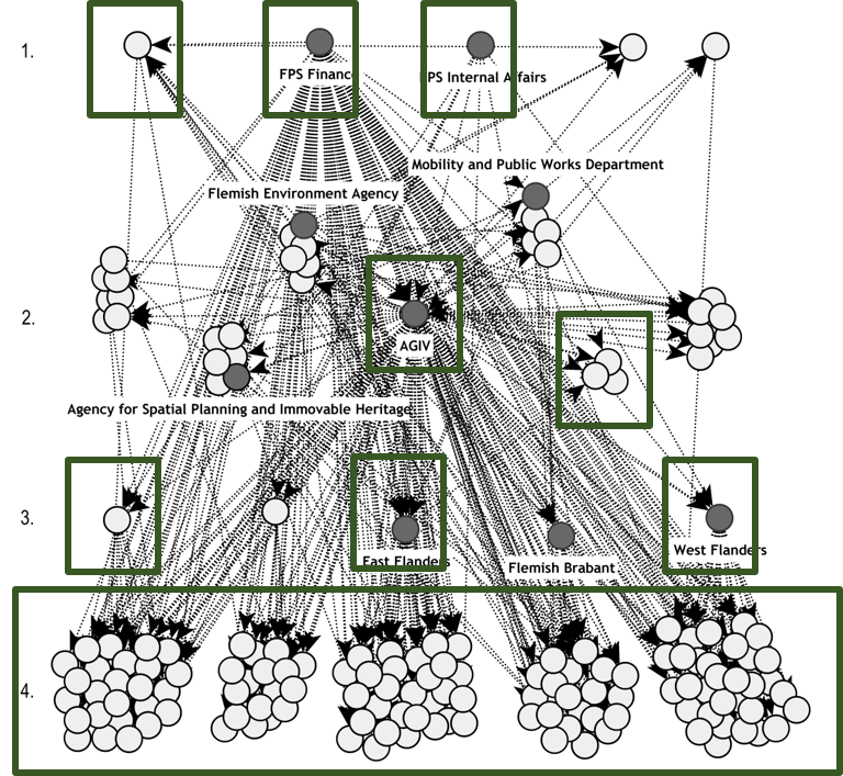
Allocation of tasks and responsibilities
- Who should be doing what?
- Who is responsible for which data set?
- Which tasks? Metadata, harmonization, services, etc.
- What is the role of non-government actors?
- Need for a clear division of tasks in order to avoid duplications, contradictions or tasks that are not executed.
- Instruments:
- Coordinating entity (new or existing organization)
- Reshuffling of tasks and competencies (different roles in SDI implementation)
Example - Allocation of tasks and responsibilities
Tasks in implementing INSPIRE
- Creation and maintenance of metadata;
- Harmonizing data according to INSPIRE data specifications (re-engineering or transformation of spatial data sets and conformity testing activities);
- Establishing and operating network services, (including the creation and maintenance of metadata for these services, as well as conformity testing)
- Determining the conditions applying to access to, and use of the data, and, where applicable, corresponding fees;
- Monitoring the use of the data and related services.
Different roles in SDI implementation
- Data user: expresses his/her needs and demands and report son the quality of data and services that are provided
- Data custodian: creates and maintains his/her own data and the associated metadata
- Service provider: deploys spatial data services on top of spatial data sets + create metadata for services
- Geo-broker: provides the technological platform that allows linking the different catalogues, catalogues services and portals to each other and provide technical support to the partners of the platform that do not have the technical knowledge and skills to set up the necessary services.
Example: Task allocation
Basic nodes:
- Produce/manage geospatial data
- Share geospatial data via traditional means (USB, DVD, e-mail)
- Have internal system for managing geospatial data (for multiple users)
- Data can be viewed online via internal/external tools or viewers
Intermediate nodes:
- Provide basic metadata for their data
- Provide standardized web map services (WMS or WMTS web map services)
- Data can be downloaded online
Advanced nodes:
- Approved metadata generation procedures
- Metadata catalogue
- Data accessible via standardized download services (WFS or WCS)
- Geodata (and services) centrally available through a geoportal
- General rules on internal management of geo-information
Creation of markets
Aim: To establish and maintain markets between stakeholders (where data providers and data users can meet)
Distinction
- Internal markets (within government)
- External markets (outside government)
Instruments:
- Portals
- Data sharing agreements
- Licenses
- Financial incentives (to support providers/users)
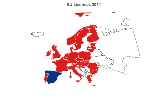
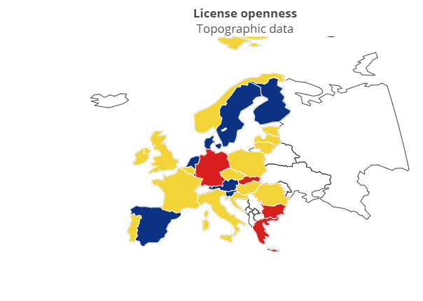

Process of harmonizing (open) spatial data licenses in Europe
2006: Each organization has its own unique set of licenses
2011: Harmonisation initiatives at national level (but hardly no open data)
2017: Use of internationally interoperable (open) licenses
See: Van Loenen, B. et al (2017). Harmonising Open Licences in the European Union: “Been there, done that. What’s next?”. Presentation at the INSPIRE 2017 Conference, Strasbourg.
Interorganizational knowledge and culture sharing
Aim: To create shared vision, norms, values and knowledge between stakeholders
Instruments:
- Information sharing
- Awareness raising
- Capacity building
Trends:
- Different types of guidance document (online)
- National GI associations contribute to awareness raising and networking
Regulating and formalizing the infastructure
Aim: To formalize the infrastructure (and governance of it) into a binding framework
Instruments:
- Agreements, Laws and Regulation (legal framework)
Trends:
- SDI legal framework prior to INSPIRE
- Transposition of INSPIRE into national legislation
Learning activity - conclusion
Can you find examples of these for your country?
- Joint decison making bodies
- Advisory bodies
- SDI Strategies and Action Plans
- SDI Assessments
- SDI coordinating entity
- Allocation of tasks, roles and responsibilities
- SDI ‘market places’: geoportals, licenses, financial incentives
- Networking and awareness raising
- Training
- Legal framework
Reference list
- Box, P. (2013). The Governance of Spatial Data Infrastructure: A Registry Based Model, University of Melbourne.
- Crompvoets, J., Vancauwenberghe, G., Ho, S., Masser, I., & de Vries, W. T. (2018). Governance of national spatial data infrastructures in Europe. International Journal of Spatial Data Infrastructures Research, 13, 253-285.
- Lance, K. T., Georgiadou, Y., & Bregt, A. K. (2009). Cross‐agency coordination in the shadow of hierarchy:‘joining up’government geospatial information systems. International journal of geographical information science, 23(2), 249-269.
- Sjoukema, J. W., Bregt, A. K., & Crompvoets, J. (2020). Understanding Governance Dynamics: The Governing System of Spatial Data Infrastructures. International Journal of Spatial Data Infrastructures Research, 15, 1-35.