SDI performance and assessment
How SDI perfom in comparison with others SDI's, learning from best practices and options for improvement
WELCOME!
The following modules give an overview of the non-technical aspects related to Spatial Data Infrastructures (SDI). This training material aims to guide and improve skills of SDI owners and managers.
This course material has been developed using tools, concepts and guidelines under the framework of the EO4GEO project. Unless stated otherwise, all rights for figures and additional material are with the author(s).
You can navigate through the course by pressing the navigation arrows at the bottom of each slide or using your arrow keys on your keyboard. You can move horizontally (← →) for viewing each theme and vertically (↑↓) to navigate through its contents.
SDI performance and assessment
1. Introduction
- Why SDI assessment is important
- The span of performance
- The depth of performance
SDI performance and assessment
Is about providing an answer to questions such as:
- How is my SDI performing?
- How is an SDI doing in comparison with other SDI’s?
- Is my SDI performing better than five years ago?
- Which SDI is the best SDI in the world?
- Why is this the best SDI in the world?
- What should I do to make my SDI better?
Learning activity (introduction)
Go to:
http://opendatabarometer.org/ (home page)
https://index.okfn.org/ (“places’ or ‘compare countries’)
Questions
Who is leading?
How is your country doing?
What does this all mean (e.g. leading in what?)?
Where’s the ‘spatial’ component?
Learning activity (introduction)
SDI assessment
SDI assessment is about measuring the performance of an SDI
SDI assessment deals with collecting, interpreting, sharing and using information on the performance of – particular aspects of – an SDI
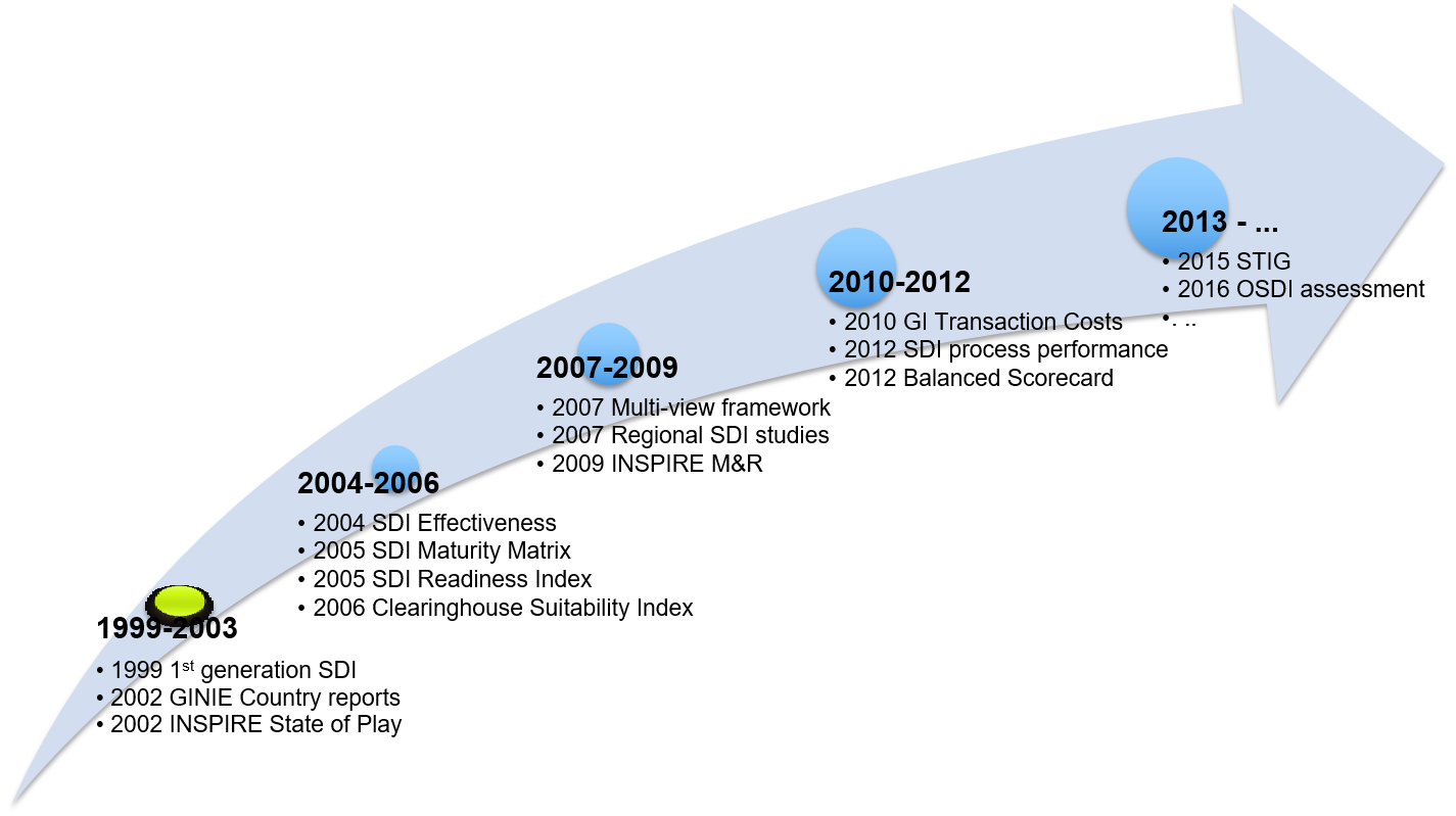
History of SDI assessment
Why assessment is important
Information on the performance (of government initiatives and policies) can be used in many different ways
In general, there are three main categories of using performance information:
- retrospective achievement: letting decision makers know in comparative terms how their country or organization is performing
- prospective direction/priorities: assisting policy makers and practitioners with strategic decision making and future implementation projects
- accountability: enabling governments and agencies to be held to account for the resources they have invested
|
|
Incorporation of performance information
- Incorporation = intentionally importing performance-related data and information in documents and procedures with the potential and purpose of using them
- Ensuring/institutionalizing the use of performance information
- Examples:
- In the policy cycle: performance information is included in policy preparation, implementation, monitoring and evaluation
- In the contract cycle: performance information is included in the design, implementation and evaluation of contracts between different parties
Example: INSPIRE
INSPIRE Directive art. 17
Network services are necessary for sharing spatial data between the various levels of public authority in the Community. Those network services should make it possible to discover, transform, view and download spatial data and to invoke spatial data and e-commerce services. The services of the network should work in accordance with commonly agreed specifications and minimum performance criteria in order to ensure the interoperability of the infrastructures established by the Member States. The network of services should also include the technical possibility to enable public authorities to make their spatial data sets and services available.
Example: INSPIRE (2)
Implementing Rule on Network Services
1. PERFORMANCE
The response time for sending the initial response to a Discovery service request shall be maximum 3 seconds in normal situation.
For a 470 Kilobytes image (e.g. 800 × 600 pixels with a colour depth of 8 bits), the response time for sending the initial response to a Get Map Request to a view service shall be maximum 5 seconds in normal situation.
Normal situation represents periods out of peak load. It is set at 90 % of the time.
2. CAPACITY
The minimum number of served simultaneous requests to a discovery service according to the performance quality of service shall be 30 per second.
The minimum number of served simultaneous service requests to a view service according to the performance quality of service shall be 20 per second.
3. AVAILABILITY
The probability of a Network Service to be available shall be 99 % of the time.
1. Introduction
2. Why SDI assessment is important
3. The span of performance
4. The depth of performance
Assessment is about performance
Many different meanings of performance:
- Between disciplines: geomatics, spatial planning, economics, social sciences, managerial sciences
- Within one discipline: no consensus on the meaning of SDI performance
To create some clarity, a distinction can be made between
- The span of performance
- The depth of performance
Span of performance
Horizontal dimension of performance
Refers to performance in terms of
1. inputs that are processed in activities,
2. these activities result in outputs (products or services)
3. which finally (should) lead to certain outcomes

Span of SDI performance
‘Performance’ of SDI can be defined and measured in various ways:
- Readiness of the infrastructure
- Organizational maturity of the infrastructure
- Suitability of the geoportal
- Level of implementation of different components
- Availability of geographic data
- Application of principles of open data
- Number of users of geographic data
- Use of geographic data in society
- Social benefits of the infrastructure
- Economic benefits of open geographic data
Span of SDI performance
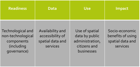
Thinking in terms of ‘input – output – outcome - impact’ to create some clarity
- Input: technological and non-technological components of an SDI
- Output: availability and accessibility of spatial data
- Outcome: use of spatial data by public administration, businesses, citizens, …
- Impact: internal and external benefits of spatial data
SDI assessment

SDI assessment

SDI assessment

Span of SDI performance
‘Performance’ of SDI can be defined and measured in various ways:
- Readiness of the infrastructure
- Organizational maturity of the infrastructure
- Suitability of the geoportal
- Level of implementation of different components
- Availability of geographic data
- Application of principles of open data
- Number of users of geographic data
- Use of geographic data in society
- Social benefits of the infrastructure
- Economic benefits of open geographic data
| Readiness |
| Data |
| Use |
| Impact |
Depth of performance
Vertical dimension of performance
Performance can be measured - and managed - at different – (interrelated) levels
Typical levels in public sector performance:
- Micro performance is at the level of an organisation
- Meso performance is at the level of a policy area
- Macro performance is government (or infrastructure) wide
Depth of performance

Apply the input – output – outcome scheme at the three levels of an individual organisation, a policy field and the consolidated government-wide level
Need to match input, activities, output and outcome/effects at micro, meso, and macro level
Depth of SDI performance
Also the performance of SDIs can be measured at different levels:
- Data sets
- Organizations
- Policy chains and policy areas
- Government wide
- Country wide (government + private sector + other sectors)
- Globally
Example: INSPIRE
Learning activity (conclusion)
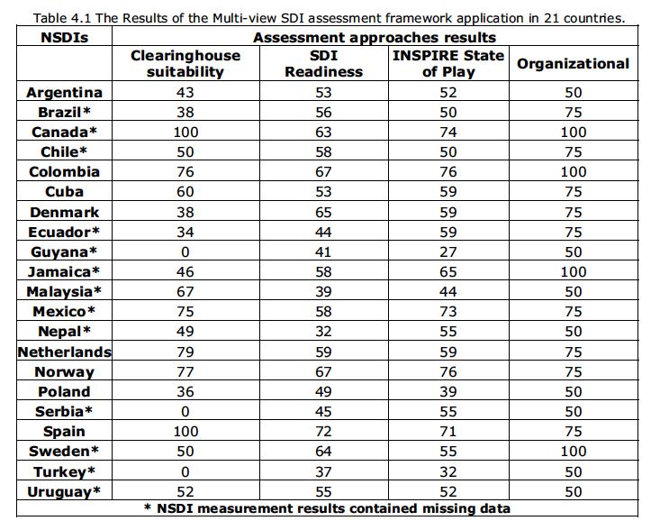
Source: Grus, 2010
Questions:
Which of the countries included in the table on the right has the best SDI? And why?
The assessment approaches used in the table apply a different span of performance. What does this mean? How could this affect the results of the assessment?
The assessment approaches could also apply a different depth of performance. What does this mean? How could this affect the results of the assessment?
What could be other reasons why different assessments of the same SDIs provide different results?
Reference list
- Crompvoets, J., Rajabifard, A., Van Loenen, B., & Fernández, T. D. (2008). A multi-view framework to assess SDIs. Wageningen University, RGI.
- Giff, G. A., & Crompvoets, J. (2008). Performance indicators a tool to support spatial data infrastructure assessment. Computers, Environment and Urban Systems, 32(5), 365-376.
- Vancauwenberghe, G., Valečkaitė, K., Van Loenen, B., & Donker, F. W. (2018). Assessing the Openness of Spatial Data Infrastructures (SDI): Towards a Map of Open SDI. International Journal of Spatial Data Infrastructures Research, 13, 88-100.