01 | SDI Architecture and SDI components
Elaboration of Standards, Norms and Procedures in the Acquisition and Dissemination of Geospatial Information
WELCOME!
With the following slides and interactive material you will be able to take part in the journey to discover Spatial Data Infrastructures (SDI) its components and benefits through the observation of multiple examples and exercises.
You can navigate through the course by pressing the navigation arrows at the bottom of each slide or using your arrow keys on your keyboard. You can move horizontally (← →) for viewing each theme and vertically (↑↓) to view extra recommended information

01 | SDI Architecture and SDI components
Elaboration of Standards, Norms and Procedures in the Acquisition and Dissemination of Geospatial Information
SDI Architecture and SDI components
01 | Geographic Information for policy making
- In Context
- Applied Examples
- Combining Datasets
EUROSION
01 | Geographic Information for policy making
Geographic Information is needed in many policy domains
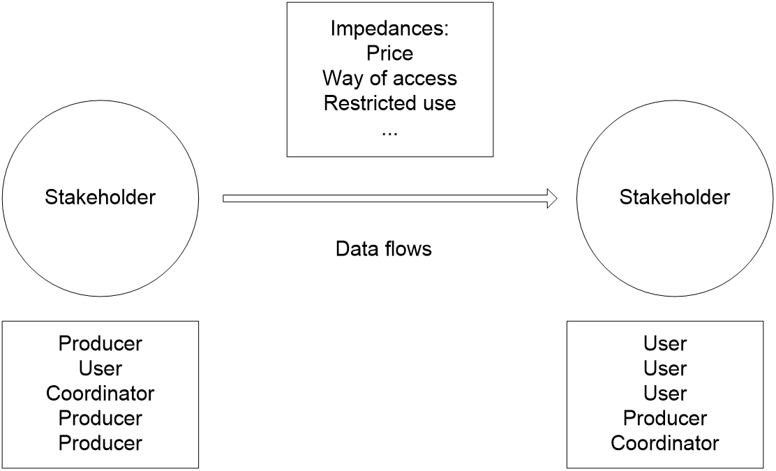
Many stakeholders and organizations produce spatial datasets but there is...
|
|
01 | EUROSION
“To provide the European Commission with a package of recommendations on policy and management measures to address coastal erosion in the EU. These recommendations should be based on a thorough assessment of the state of coastline and of the response options available at each level of administration.”
01 | 01 Applied Examples
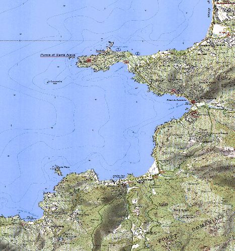
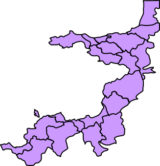
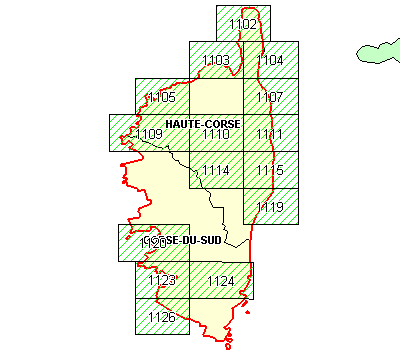
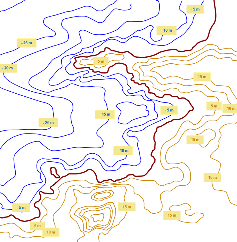
| Example of Ajaccio Bay |
01 | 02 Combining Datasets
02 | Combining Geographical Data
- Common Issues
- Summary
- Exercise
02 | Common Issues:
- A large variety of formats exist
- Many geographical gaps still remain
- Reference systems are not harmonized
- Many data sources are not consistent
- Scales are not compatible
- All data are not interoperable
- Costs and access restrictions
02 | Issue No. 1 - A large variety of formats exists

02 | Issue No. 2 – Many geographical gaps still remain
Geological data at scale 1:50,000
(source: BRGM, France)
Need to identify the gaps and make priorities to bridge them
02 | Issue No. 3 - Reference systems are not harmonized
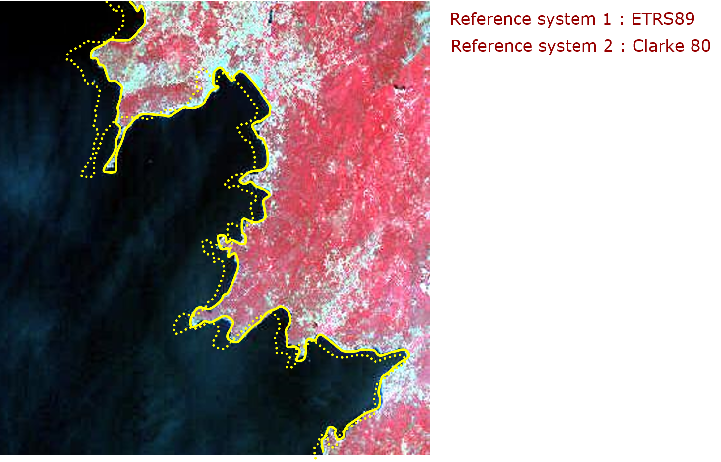
Need to define a common terrestrial reference system for data production and processing
02 | Issue No. 4 – Many data sources are not consistent
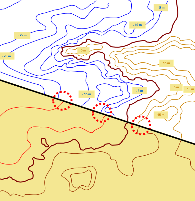
Need to build pan-european “seamless” data with standard specifications
Sources 1:
Coastline : SABE (EuroGeographics)
Bathymetry : TCIFMS (SHOM)
Topography : BDTOPO (IGN)
Sources 2:
Coastline : SABE (EuroGeographics)
Bathymetry : GEBCO (BODC)
Topography : MONA PRO
02 | Issue No. 5 - Scales are not compatible
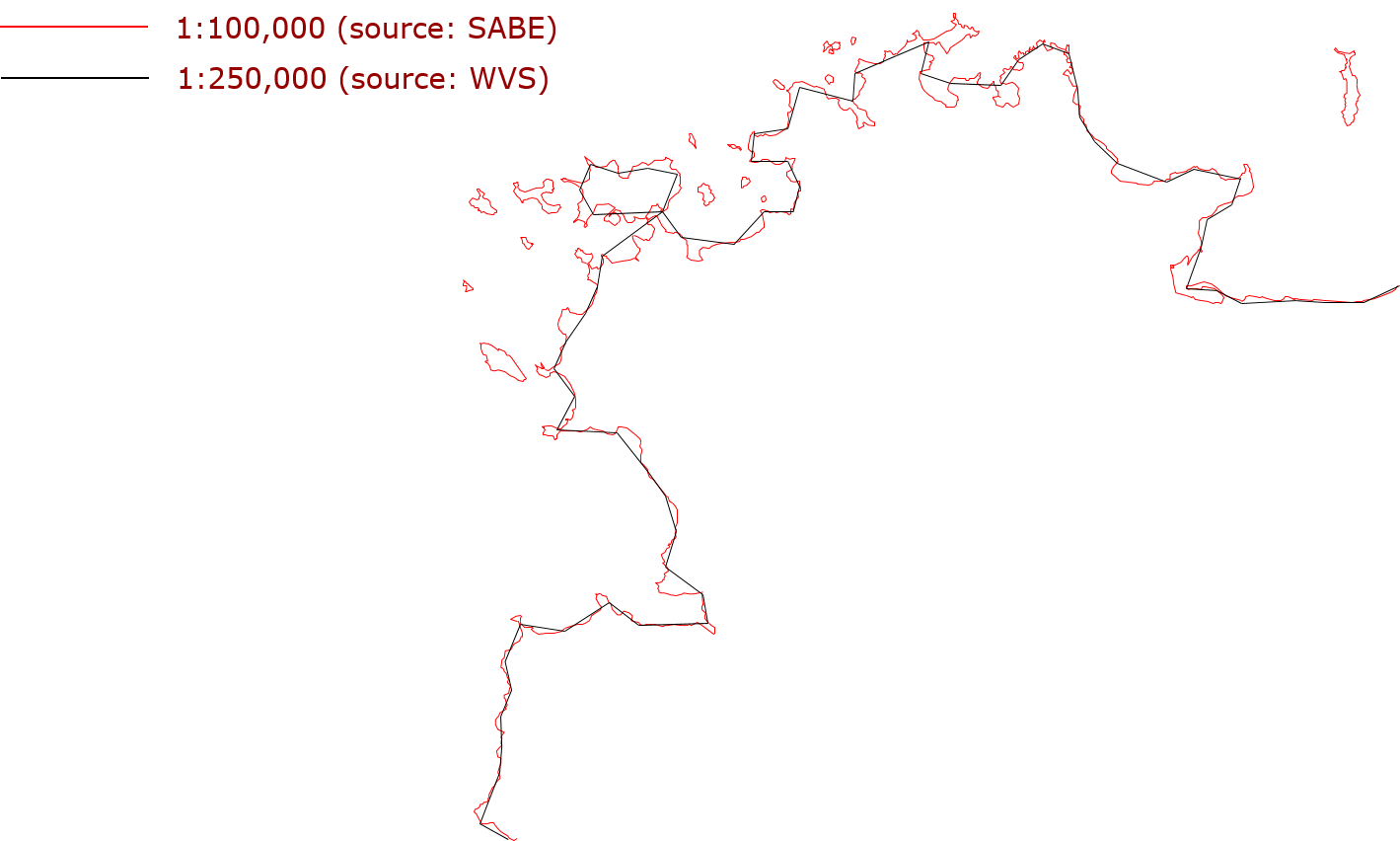
Need to adopt a common level of perception and representation of data
02 | Issue No. 6 – Data not interoperable
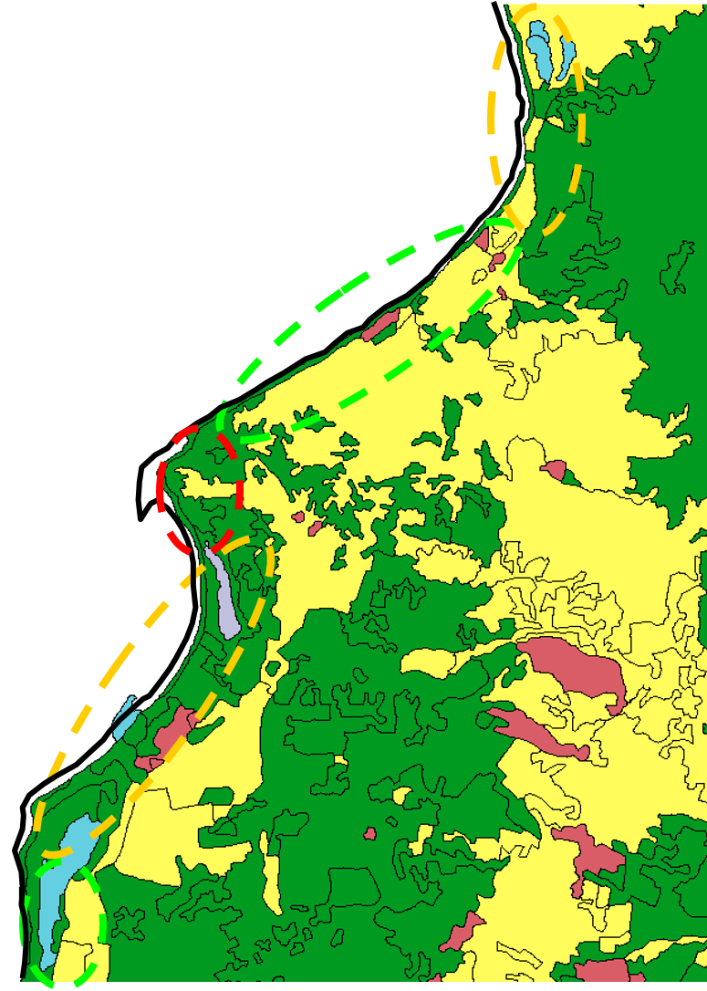
CORINE Land Cover 1990
SABE Coastline
0 m < Difference < 50 m
50 m < Difference < 200 m
Difference > 200 m
02 | Issue No. 7 – Costs and access restrictions
- Most existing datasets are “copyrighted”: you do not buy information itself, but a right to use it (“license”)
- Dissemination of end-products is restricted (sometimes, end-products have to be “degraded”)
- Quality “label” are not commonly adopted: uncertainty about the products
02 | Issue No. 7 – Costs and access restrictions
EUROSION database = 2 Millions Euros
- 26% acquisition of licensed data (e.g. Elevation)
- 17% update of existing data (e.g. Coastal Erosion)
- 33% production of missing data (e.g. Hydrodynamics)
- 24% Format conversion, integration, and quality control
02 | Summary
The absence of a European spatial data infrastructure results in:
- Higher investment costs (2 to 3 times)
- Delayed implementation (8 to 10 months)
- Uncertain quality
- Dissemination constraints
There is a need for developing an infrastructure that provides direct access to harmonized (interoperable) data and that can be shared amongst all those that need it
03 | SDI definitions and approaches
- Common definitions and approaches
- GIS and SDI
03 | 01 SDI definitions and approaches
Many attempts to define and conceptualize SDI
Focus on the components (spatial data, technology, policies, standards and people)
Recognizing its dynamic nature (evolution)
Identifying (data) sharing as a key issue
Describing different views of SDI hierarchy
- Rajibifard
- Masser
- Chan
- GSDI
- ...
03 | 02 SDI definitions and approaches
03 | 03 SDI definitions and approaches
|
03 | 04 SDI definitions and approaches
03 | 05 GIS and SDI
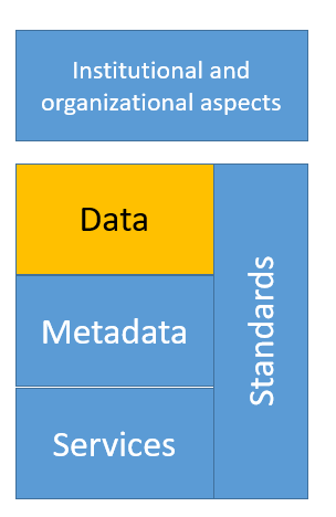
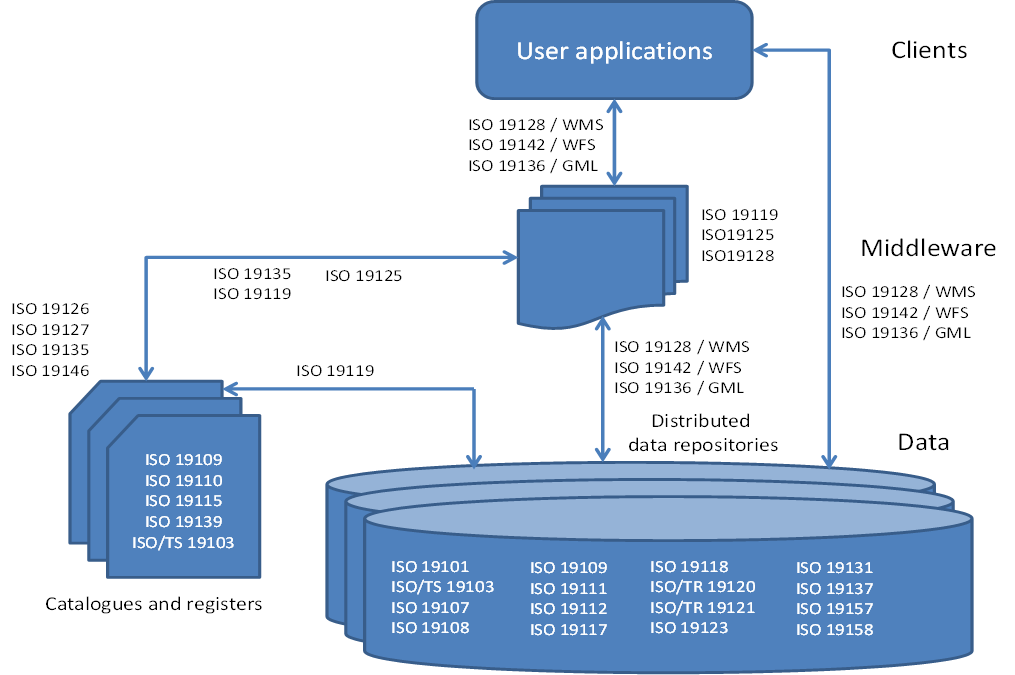
04 | SDI Components
- Principal components
- Data specifications
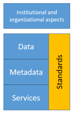
04 | 01 SDI Components
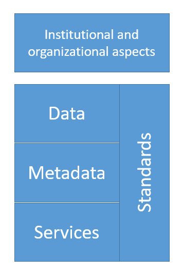
04 | 01 SDI Components
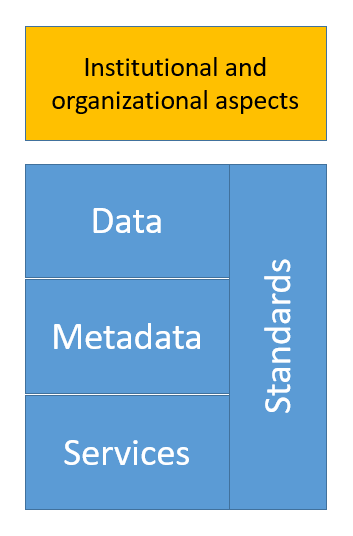
04 | 01 SDI Components
|
Laws or voluntary agreements governing the collaboration between producers and/or users of geodata. An organizational structure; mandates; who does what? - Mechanisms for financing the SDI and its coordination |

|
Laws/agreements about pricing and licensing of geodatasets: |
Laws/agreements about how to deal with: | |
|---|---|---|
|
|
04 | 04 SDI Components
04 | 05 SDI Components
REFERENCE GEODATASETS:
Required in almost every application as the geometric foundation
- "Stable" topographic entities (roads, water courses, administrative boundaries)
- Orthophotographs
- "Stable" terrain characteristics (elevation, ...)
04 | 06 SDI Components
REFERENCE (CORE) THEMATIC GEODATASETS:
Useful for several thematic domains
- Land cover and land use
- Spatial destination
- Soils
- Geology
04 | 06 SDI Components
Datasets are standardized and kept in repositories, ‘somewhere’ in the infrastructure/on the network
- ‘Big Data’, but highly structured and standardized
- ‘Cloud’ but highly structured
01 | 05 Data specifications
05 | 01 Data specifications
| Application schema (defines the model) |
 |
Data harmonization
|
05 | 02 Data specifications
It is about more than the dataset alone
 |
This is reflected in the geospatial standards! |
06 | Services
- Services for SDIs
- View services
- Download services
- Transformation services
- Catalgue service for the web CSW
- Rights management services
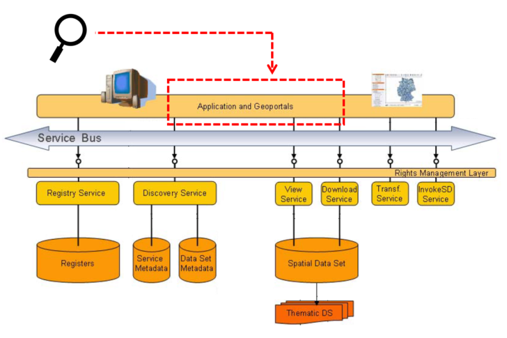
06 | 01 Technological components of SDI: services
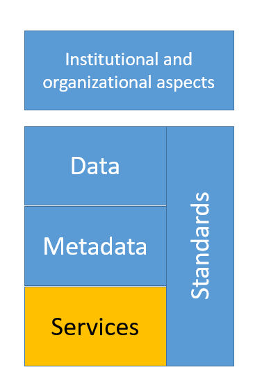
06 | 02 Technological components of SDI: services
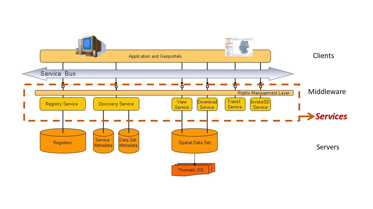
06 | 03 Services for SDIs
MOST IMPORTANT SERVICES:
- View services (WMS)
- View data (as image)
- Download services (features WFS, coverages WCS)
- Transformation services (WPS, processing)
- Often in the background (e.g. coordinate transformation)
- Discovery services (CSW, Catalogue)
- Provider publishes data
- User finds the data and access services
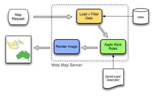
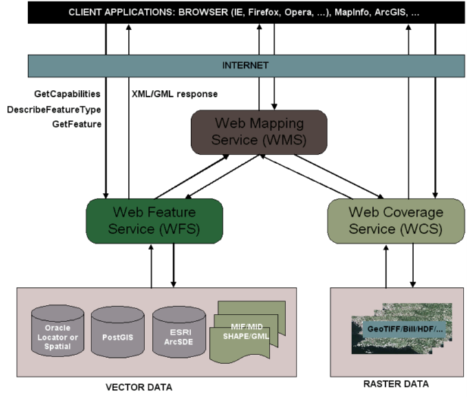
06 | 04 View Services: Web map services WMS
- As its name implies, is a service that provides maps.
- Data only leaves the server as an image
- Map is rendered on the server so styling and presentation is chosen by the data provider
- Limited client interactivity with the map
06 | 05 View Services: Web map services WMS
Note: source material (data) from which the image is generated does not need to be an image, but can be a Shapefile, PostGIS database, Oracle Spatial,…
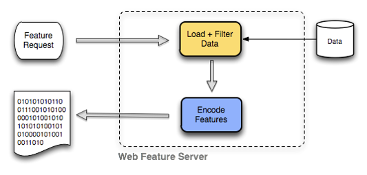
06 | 06 Download Services:Web feature services WFS
- Provides map data (GML) to a (web) client
- The client chooses style & presentational details
- Geospatial features
- Selection query for features in the request
- Requesting predefined datasets
- Optional: Transactional Web Feature Service (WFS-T) enables the creation, deletion, and updating of features
06 | 07 Download Services:Web feature services WFS
06 | 08 Transformation services: Web processing services WPS
- Requests the execution of a spatial calculation
- One of the benefits of WPS is its ability to chain processes
- A WPS process can use as its input the output of another (previous) process
- Many complex functions can thus be combined in to a single powerful request
- Example: transform coordinates from CRS in database to CRS requested by user
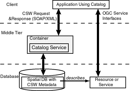
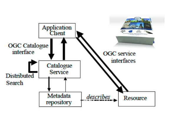
06 | 09 CSW – Catalogue Service for the Web
|
 |
06 | 10 Services
Service chaining: different services combined to produce the output
06 | 11 Services
Publish – Find – Agree - Bind
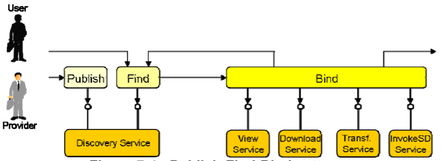
06 | 12 Rights management services
The ‘agree’ part: rights management services
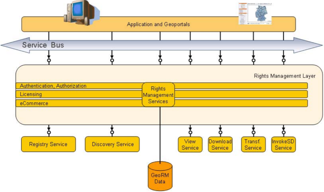 |
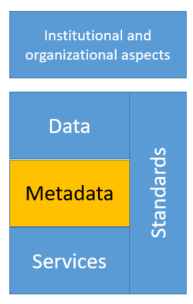
Related to the Institutional and organizational aspects of SDI |
06 | 13 Service oriented architecture
06 | 14 Service oriented architecture
Different technical services and components are distributed over the net.
Talk to each other through APIs
If standardised, components from different software providers can talk to each other
Standards are needed!
07 | Standards
- Definition
- Standardization bodies
- ISO/TC211
- Open Geospatial Consortium OGC
07 | 01 What are standards?
Standards are everywhere

07 | 02 What are standards?
Standards are...
“Documented agreements containing technical specifications or other precise criteria to be used consistently as rules, guidelines, or definitions of characteristics, to ensure that materials, products, processes and services are fit for their purpose”
(ISO, 2019)
07 | 03 What are standards?
 |
|
“The interesting thing about Standards is that there are so many to chose from…” |
07 | 04 Standardization bodies
Many standardization bodies exist

07 | 05 ISO/TC211
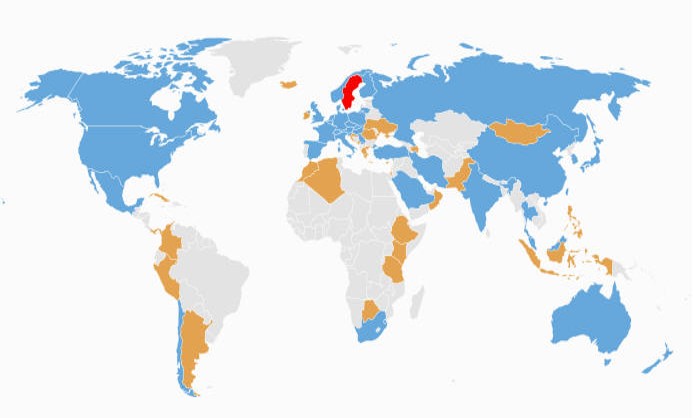
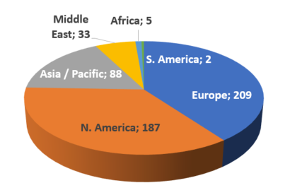
38 Participating Members, 31 Observing Members
07 | 06 Open Geospatial consortium OGC
Not-for-profit, international voluntary consensus standards organization; leading development of geospatial standards |
 |
|
07 | 07 Open Geospatial consortium OGC
A document, established by consensus and approved by the OGC Membership, that provides rules and guidelines, aimed at the optimum degree of interoperability in a given context.
|
 |
07 | 08 Types of standards
Different types of standards: technical and semantic
07 | 09 Types of standards
In summary:
technical standards will make you connected, while semantic standards will make you understood (Reuvers, 2005)


07 | 10 Types of standards
Different types of standards: de facto and de juro:
- De facto:
- e.g. SQL, SHP, KML
- Open Geospatial consortium standards
- De jure (legal)
- ISO/TC 211
- CEN/TC 287
- Federal Geographic Data Committee (FGDC, USA)
Sometimes a de facto standard is formally adopted (e.g. KML)
07 | 11 Standards for SDI
Standards for
|
 |
07 | 12 Data related standards for SDI
Standards for data (semantic!)
More than exchange formats. Specify what must be included in datasets and how it must be stored
Focus on standardised conceptual/logical data models and data specifications (UML)
Standards and specifications related to geographical objects
07 | 13 Service related standards
Standards for services (How it works: technical!)
OGC standards (often also covered by ISO) for use with all kinds of client-server combinations
- Web Map Service (WMS, ISO 19128)
- Web Feature Service (WFS, ISO 19142)
- Web Coverage Service (WCS)
- Web Processing Service (WPS)
Similar to the services available in an SDI!
07 | 14 Service related standards
Define information about data or services, needed to search, explore, assess, connect to available resources
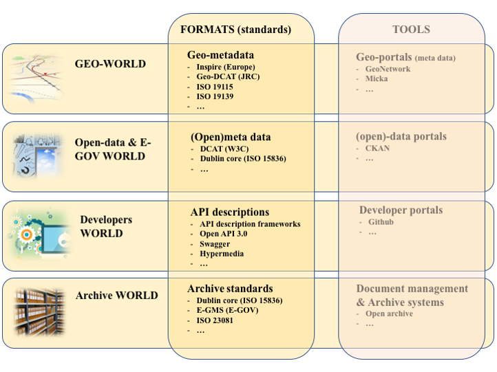
08 | Metadata
 |
|
08 | 02 What are metadata
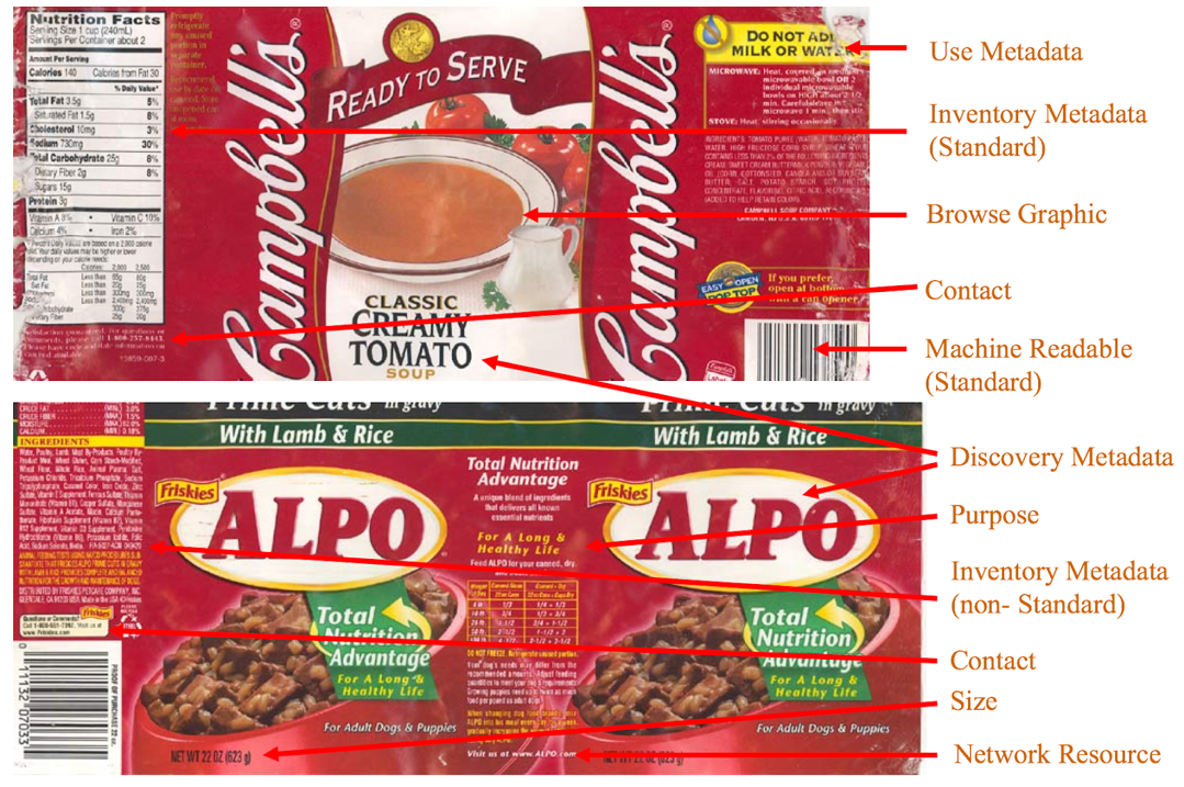
Metadata are everywhere Metadata can be found on all consumer products in our food chain (check a coca cola can) or any other product for that matter. It gives you information on who produced/delivered the product and how you can contact them, a description of the product, it provides a (bar-)code with unique identifier, a ‘preview’ of the product, information on how to use the product (or not), the ingredients, information about the quality, the validity date (the date it was produced and the date until you can consume it), the size/volume, etc. |
 |
08 | 03 What are metadata used for?
|
Inform the user about
|
|
Usually the metadata are mandatory and standardized!
08 | 04 Metadata for different communities…
 |
Different communities,other standards The Dublin Core standard is used for documenting reports, archiving files, etc. It consist of several elements to understand the document / file:
|
08 | 05 Storage of (geospatial) metadata
Where storing metadata? |
 |
08 | 06 Storage of (geospatial) metadata
A catalogue allows you to group the metadata records together and to expose the information via the web through a ‘discovery’ or catalogue service. The latter allows to have all information on datasets (and services) of the SDI in one place. |
 |
08 | 07 Types of (geospatial) metadata
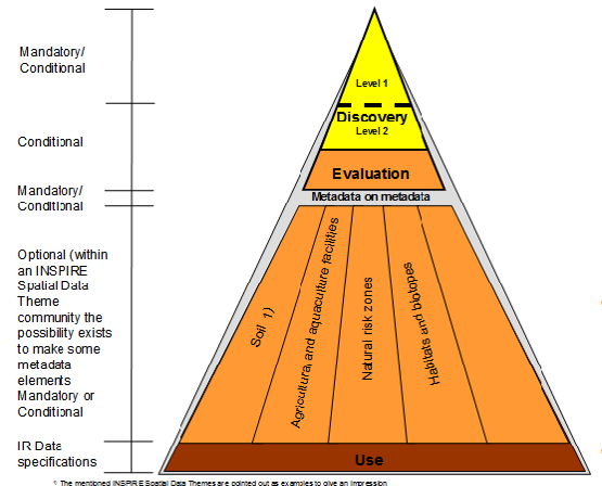 |
Different types for different purposes |
08 | 08 Metadata Schema
It is recommended to start with the mandatory metadata elements which are required for discovery purposes and which are ‘easy’ to maintain: e.g. title, abstract, reference date, language, topic category. Usually metadata elements are grouped.
Some optional elements are also recommended: e.g. responsibility party, lineage, online resource.
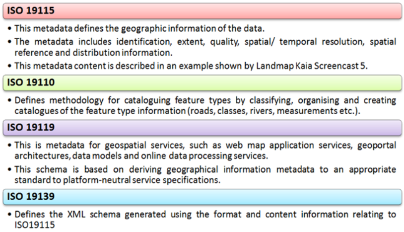
The table shows the so-called core elements of the ISO 19115:2003 standard.

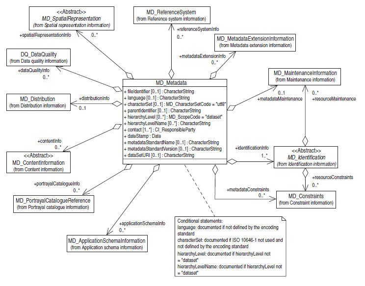
08 | 09 Metadata Schema
Schema consists of metadata elements.
|
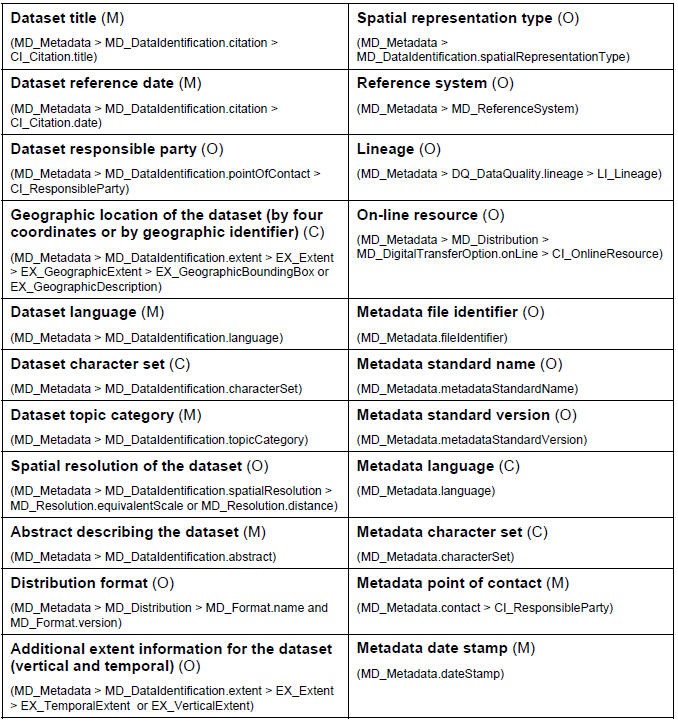 |
08 | 10 Mandatory elements
 |
The core metadata elements answering the following questions: |
08 | 11 Identification elements
|
Identification information contains information to uniquely identify the data. Identification information includes information about the citation for the resource (title), an abstract, an identifier, keyword(s), the purpose, credit, the status and points of contact. The MD_Identification entity is mandatory. It contains mandatory, conditional, and optional elements. 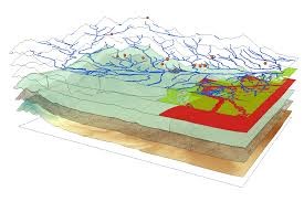
|
Identification elements
Title - Should be self-explaining and not too long – don’t use the filename of the resource! Abstract - Should be concise and explain what the dataset is about, usually 1/3 to ½ page text Identifier - a unique code for the resource, not automatically generated but part of a PID strategy for information infrastructures Keyword(s) - the topic(s) covered by the dataset; might use an existing vocabulary (e.g. GEMET) Format - vector or raster data Type - it can be a dataset, a dataset series or a web service |
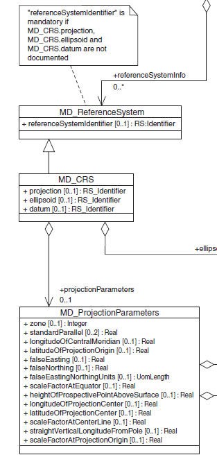
08 | 12 CRS and other elements
Coordinate Reference System is referring to the projects, the ellipsoid and datum of the dataset including a link to the CRS type (code list) and projection parameters. |
 |
 |
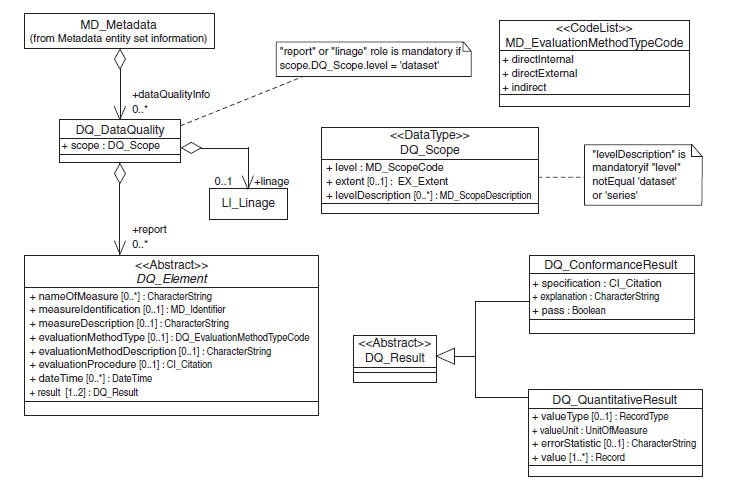
08 | 13 Data Quality elements
Data Quality contains a general assessment of the quality of the dataset. Data Quality is an aggregate of the Lineage and Data Quality Elements. The latter can include following elements: completeness, logical consistency, positional accuracy, thematic accuracy and temporal accuracy. Those five entities can be further subdivided to the sub-elements of data quality. |
 |
08 | 14 Constraint elements
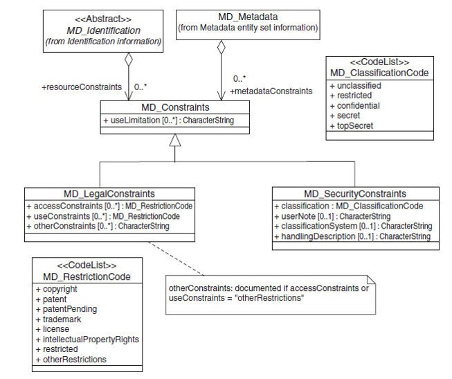 |
Constraints can impose limitations of sharing and use. The reasons might be variable. Sensitive information such as personal or military information might need to be secured, or vulnerable species or habitats might be protected as well. On the other hand there might be legal constraints related to the existence of copyrights, patents or licenses (paying fees), or there might be some restrictions on what users can do with the data. |
09 | Geoportals
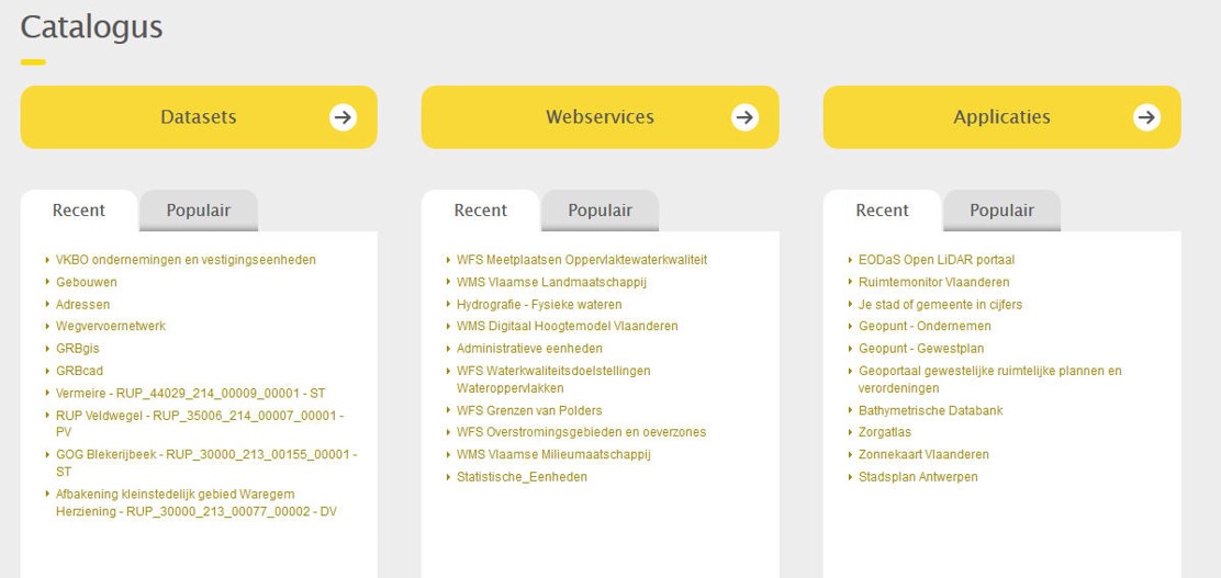
- How to find information
09 | 01 Geoportals How to find geographic information
Geoportals as one of the possible applications to connect to the geographical (meta)data
09 | 02 Geoportals
| Key component of a SDI |
 |
Some definitions and characteristics:
“A geoportal may be defined as an internet or intranet entry point with the tools for retrieving metadata, searching for GI, visualizing GI, downloading GI, disseminating GI and in some cases the ordering of GI services”
(Giff et al., 2008)
10 | Concepts Exercise
Reference list
- Craglia, M., & Annoni, A. (2007). INSPIRE: An innovative approach to the development of spatial data infrastructures in Europe. Research and theory in advancing spatial data infrastructure concepts, 93-105.
- Granell, C., Gould, M., Manso, M. A., & Bernabe, M. A. (2009). Spatial data infrastructures. In Handbook of Research on Geoinformatics (pp. 36-41). IGI Global.
- Rajabifard, A., & Williamson, I. P. (2001). Spatial data infrastructures: concept, SDI hierarchy and future directions.
- Schade, S., Granell, C., Vancauwenberghe, G., Keßler, C., Vandenbroucke, D., Masser, I., & Gould, M. (2020). Geospatial Information Infrastructures. In Manual of Digital Earth (pp. 161-190). Springer, Singapore.
- Williamson, I. P., Rajabifard, A., & Feeney, M. E. F. (Eds.). (2003). Developing spatial data infrastructures: from concept to reality. CRC Press.