Metadata and Catalog Services
What metada and data catalogs are, their use in geographic information, their quality and where to find them in geoportals
WELCOME!
With the following slides and interactive material you will be able to take part in the journey to discover Spatial Data Infrastructures (SDI) its components and benefits through the observation of multiple examples and exercises.
You can navigate through the course by pressing the navigation arrows at the bottom of each slide or using your arrow keys on your keyboard. You can move horizontally (← →) for viewing each theme and vertically (↑↓) to view extra recommended information

Metadata and Catalog Services
01 | 01 What is metadata?
What is metadata?
Metadata is like onions...


Entrance door
What is metadata?
Description of data
Content


Map documents
Layers
Geodatabase datasets
Non-spatial table
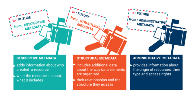
Data about data.
Data data
Data on data or “a love note for the future”:
“The metadata, as you see, are really a note of love — it can be itself, but it is in fact a note of love for the person or maquine who after you saved him time to know what they have found.” (Scott)
Data about data
- Data set data
- Tool data
- Services data
- Lectures data
- ......
Basic metadata example
Food in refrigerator
How do you know what each container contains?
What is the period of validity?
How to prevent dethioations?
How to store products by categories?
How to catalogue the allergens?
(...)


Resource documentation
What?— Name, fineness, small description of available resources;
Who? — Producer, owner
Where?— Coordinates, place(s)
Why?— Provision for collecting data
When?— Time information and maintenance
How?— Access to data, data lineage

Data — Geographic Information
What to do with the geographical information?
Data sharing
Easy to access
Manageability
Easy data processing
Storage of various types of data
Useful and accurate information analysis
Organisational needs
Consistency and safety
Creation Metadata


Metadata — key concepts
- Knowledge of reality
- Metadata
- Management of relational databases
- Tools and techniques in Geographic Information Systems
Metadata — Problem
Obtaining the geographical information of the different sources in the country where most of the data used by governmental institutions have a spatial nature
Gathering, mapping and cataloguing the different types of information available has a high cost
Manage large amounts of information
Norms and Standardise concepts
Metadata Creation
A lot of information is collected by different actors, repeatedly and if the information is not searchable, available and up to date, it is difficult to find
- What does the metadata tell us about the meaning of the data?
- What data do we care about and when was it produced?
- Who was the producer? How was it produced and why (objectives)?
- When produced from other data, what was the data?
- What was the initial source of this data?
If these questions are not answered, how can we assess whether or not these data interest us? Whether or not it is correct and serves our purposes.
What metadata for what?
A short reminder!
In summary, spatial data should be:
- Searchable
- Accessible/widely available (but not always free)
- Recoverables
- Understandable
- Usable

Norms and standards for metadata
- Dublin core
- Federated Geographic Data Committee (FGDC)
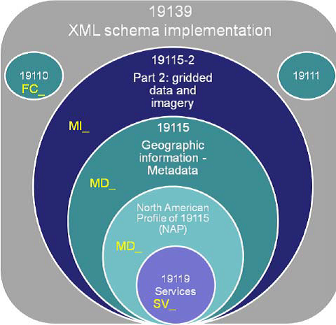
- ISO * 19139/19115 (date)
- ISO 19139/19119 (services)
- INSPIRE * * Metadata Implementing Rules
___
* International organisation for standardisation (ISO)
* * Infrastructure for Spatial Information in Europe (INSPIRE)
Dublin Core (DC) metadata
Dublin Core is a metadata schema to describe digital objects such as video, sounds, images, text and web sites.
Source:https://pt.wikipedia.org/wiki/Dublin_Core
DC Simple:contain
15 metadata elements
CC Qualification:
Other Additional Items
Qualification of standard DC
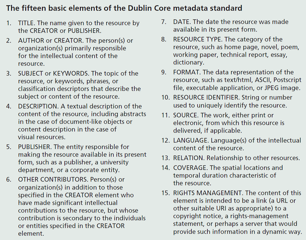
Source:Longley et al., 2005
ISO for metadata
ISO 19139/19115
ISO 19115
(metadata creation)
TC Standard 211
(metadata standardisation)
Metadata schema
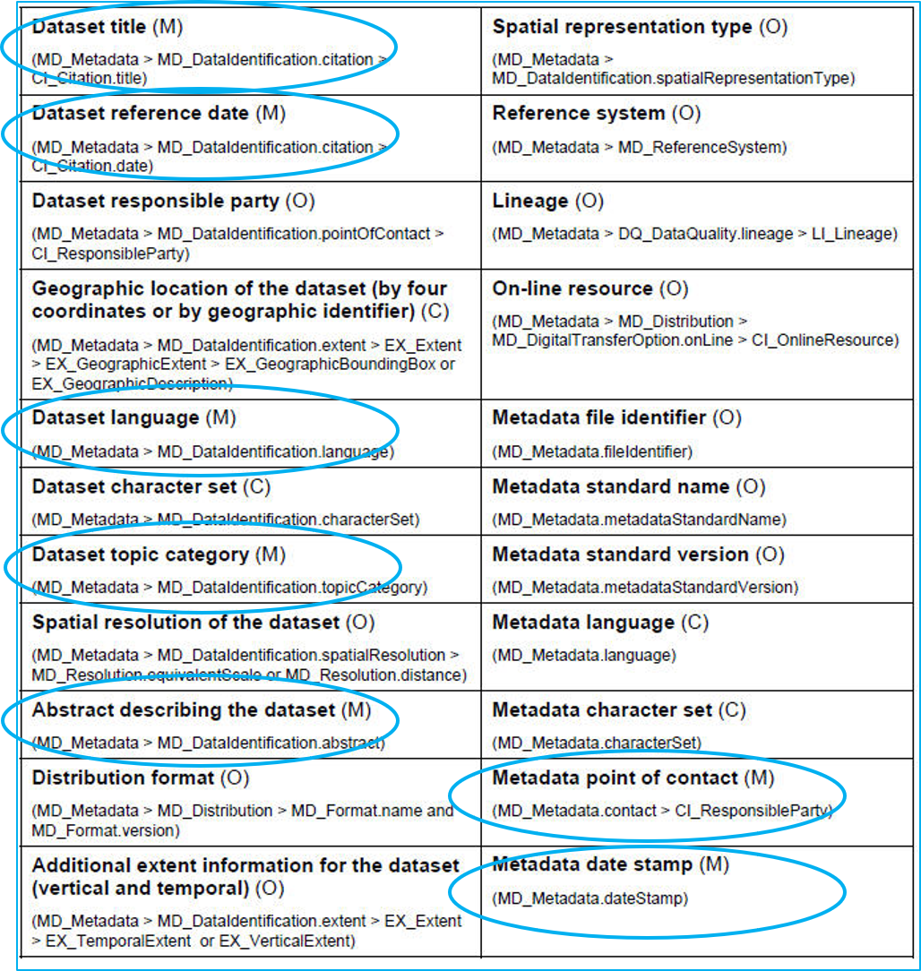
The schema consists of metadata elements.
Some are:
M — Mandatory
O — Optional
C — Conditional
It is recommended to start the mandatory metadata elements that are needed for search purposes and that are “easy” to maintain: Title, summary, reference date, language, thematic category.Metadata elements are usually grouped together.
Some optional elements are also recommended: for example, liability, online data, online services.
The table shows the key elements of ISO 19115:2003.