The EO4GEO project
The Space/Geospatial Sector Skills Alliance
Towards an innovative strategy for skills development and capacity building in the space geo-information sector supporting Copernicus User Uptake
The presentation is also available in the following languages:
 |
Italian |

|
Spanish |

|
German |
EO4GEO is an ERASMUS+ Sector Skills Alliance
Sector Skills Alliances are transnational projects which aim to tackle skills gaps with regard to one or more occupational profiles in a specific sector through a coherent and comprehensive set of activities and outputs.
key figures
- Duration: 4 years from January the 1st, 2018
- Budget: 3,87 million €
- Partnership: 25 Partners + 30+ Associated Partners (from 16 EU Countries) from Academia, Companies and networks
- Coordinators: GISIG (General), KU Leuven (Scientific & Technological), PLUS (Education & Training), Climate-KIC (Exploitation)
The VISION
To foster the growth of the European Earth Observation / Geographic Information (EO/GI) sector ensuring a workforce with the right skills, in the right place, at the right time.
The MISSION
To ensure the strategic cooperation among stakeholders on skills development in the EO/GI sector.
Strategic importance
EO4GEO aims at implementing a new approach (“Blueprint”) in the Space/Geospatial Sector:
- To improve the quality and relevance of training and other ways of acquiring skills
- To make skills more visible and comparable
- To enable people make better career choices, find quality jobs and improve their life chances
The "user uptake" context
Most EO4GEO partners are part of the Copernicus Academy Network .
EO4GEO is linked to the Copernicus Building Skills Action , aiming to:
- Increase the number of people able to access and use Copernicus data and information (basic users and/or advanced/innovative users of Copernicus)
- Increase the supply of skills to stimulate the growth of geospatial-related jobs in Europe

The strategy
- Identifying the supply of GI and EO education and training at the academic and vocational levels.
- Identifying the current demand for GI and EO skills and occupational profiles.
- Assessing the skills shortages, gaps and mismatches between supply and demand.
- Analysing trends, challenges and opportunities in the GI and EO sector.
- Defining a GI and EO sector skills strategy for skills development.
The instruments
- An ontology-based Body of Knowledge (BoK) for the space/geospatial sector (extending the existing GI BoK with EO/Copernicus concepts).
- A set of BoK-based innovative tools.
- A series of curricula and a portfolio of training modules directly usable in the context of Copernicus and other relevant programs.
- A series of learning actions for a selected set of strategeic scenario’s in three sub-sectors to test the approach.
- A Long-term Action Plan to be endorsed to roll-out and sustain the proposed solutions.
- The support of a strong group of Associated Partners mostly consisting of associations or networks active in space/geospatial domain.
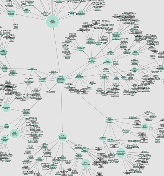
An Ontology-based Body of Knowledge
A Body of Knowledge (BoK) is the complete set of concepts and relations between them, that make up a professional domain that can be used by members of a discipline to guide their education and work practice.

|
Describing the Geographic Information and Earth Observation domain is done by defining the underpinning inter-related concepts (theories, methods, technologies, etc.) that should be covered in education and training curricula. |
But, what is a Concept?
A concept is a theoretical construct that has been formed by combining particular instances into a general idea.
|
|
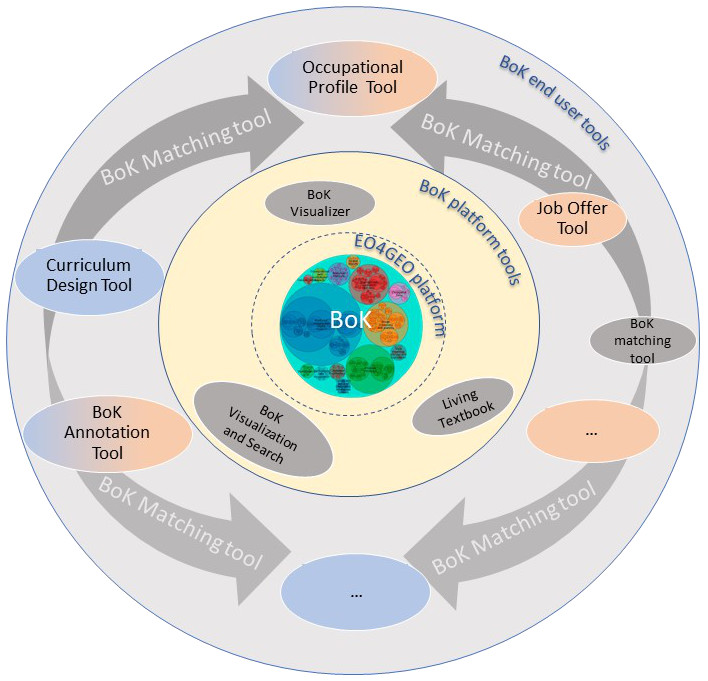
Innovative and open tools
A set of independent yet collaborating tools with the Body of Knowledge at the centre
|
EO4GEO BoK Platform allows the following functionalities:
|
EO4GEO's open tools making use of the BoK
- Curriculum Design tool: Create, edit and find EO & GI Curriculum using concepts from the EO4GEO Body of Knowledge.
- BoK visualisation and search: Auxiliary tool to search terms in BoK concepts. The tool shows matching results, and allows navigating graphically and textually in the BoK.
- Occupational Profile tool: This tool allows to create occupational job profiles and connect them with BoK concepts (Knowledge) and ESCO (skills).
- Job Offer tool: This tool allows to create job offers based on occupational profiles.
- BoK Matching tool: This tool allows to compare two annotated BoK resources, as metadata "annotated" PDFs or a EO4GEO resource created in the other tools.
- BoK Annotation Tool: This tool allows to easily annotate (associate) any PDF document with EO4GEO BoK concepts.
EO4GEO is much more
- A series of pre-defined curricula in support of Copernicus.
- A portfolio of training modules directly usable in the context of Copernicus and other relevant programs.
- A series of training actions (webinars, academic courses, etc.) in three sub-sectors - integrated applications, smart cities and climate change.
- A mobility program to promote internships and on-the-job training.
- A Long-term Action Plan to sustain the proposed solutions.
Follow us and get engaged!
- Join the Sector Skills Alliance .
- Join as an expert to revise / feed the Body of Knowledge.
- Subscribe to our project Newsletter.
- Connect your project and establish synergies.

|
www.eo4geo.eu |

|
@EO4GEOtalks |